Landslides and Topography: Shaping Landscapes 🌍
Explore how landslides influence topography and sediment spread, affected by rock uplift rates. Full details at https://doi.org/10.1029/2022JF006745.
Earth Surface Models
645 views • Aug 26, 2022
About this video
The role of landslides in shaping topography under varying rock uplift rates.
For a full description, see: https://doi.org/10.1029/2022JF006745.
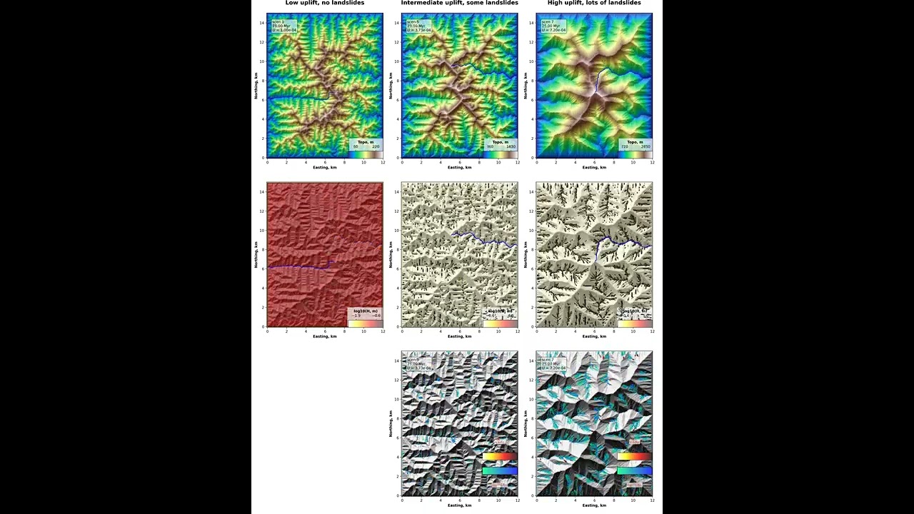
Under low uplift rates (left column), only fluvial processes shape the landscape, resulting in a dense fluvial valley network characterized by strongly concave upward river profiles. Sediment thickness approaches a uniform value under steady state where uplift balances erosion (second row). When uplift increases (second column), relief increases and landslides start to occur. This is visible in the third row of plots where landslide erosion is indicated in red and deposition in blue. Under high uplift rates, relief further increases triggering more landslides. This results in mobile fluvial networks and sediment accumulation in the fluvial valleys. During the first 10 Myr, plots are shown every 250 kyr. Between 10 Myr and 225 Myr, plots are shown every 5 Myr.
For a full description, see: https://doi.org/10.1029/2022JF006745.
Under low uplift rates (left column), only fluvial processes shape the landscape, resulting in a dense fluvial valley network characterized by strongly concave upward river profiles. Sediment thickness approaches a uniform value under steady state where uplift balances erosion (second row). When uplift increases (second column), relief increases and landslides start to occur. This is visible in the third row of plots where landslide erosion is indicated in red and deposition in blue. Under high uplift rates, relief further increases triggering more landslides. This results in mobile fluvial networks and sediment accumulation in the fluvial valleys. During the first 10 Myr, plots are shown every 250 kyr. Between 10 Myr and 225 Myr, plots are shown every 5 Myr.
Tags and Topics
Browse our collection to discover more content in these categories.
Video Information
Views
645
Likes
7
Duration
0:17
Published
Aug 26, 2022
Related Trending Topics
LIVE TRENDSRelated trending topics. Click any trend to explore more videos.